

US Navy
![]()
Marine Species Monitoring
Occurrence of Rice's Whale in the Northern Gulf of Mexico
Introduction & Objectives
Rice's whale (Balaenoptera ricei; formerly Gulf of Mexico Bryde's whale) is estimated to have a population size of 51 individuals in U.S. waters (Garrison et al. 2020) and was listed as endangered under the ESA in 2019. The majority of modern sightings occur within waters between the 100- and 400-meter (m) isobaths within an area near the De Soto Canyon off northwestern Florida (Soldevilla et al. 2017; Rosel et al. 2021), an area defined as the Rice’s whale core distribution area (Rosel and Garrison 2022). Occurrence patterns from long-term passive acoustic monitoring (PAM) over the 2010–2018 period and from summer and fall visual surveys during 2018 and 2019 indicate that the whales are found year-round within the core distribution area, but also suggest there may be seasonal movements throughout, and potentially out of, this area. High densities of anthropogenic activities occur throughout the Gulf of Mexico (GOM), including oil and gas exploration and extraction, fisheries, shipping, and military activities. Many of these activities, including U.S. Navy readiness training and testing, and Eglin Air Force Base activities, overlap with the whales’ core distribution area. Understanding seasonal distribution and density of Rice’s whales throughout the core distribution area will improve understanding of potential impact of human activities in this area, improve the accuracy and precision of impact assessments, and assist in developing effective mitigation measures as needed.
Technical Approach
To improve management of human-based activities in the core distribution area of these endangered whales, the Southeast Fisheries Science Center (SEFSC) began deploying a sparse array of 17 PAM units concurrent with one long-term HARP in May 2021. The PAM moorings were deployed in two lines of nine units each to nearly completely cover the core distribution area over a nearly 2-year period to improve understanding of seasonal and inter-annual distribution, movement patterns, and habitat use. The moorings use SoundTrap ST500 or ST600 STDs, calibrated long-term recorders capable of continuously recording underwater sound in the 20 Hz to 48 kHz frequency range, including Rice’s whale calls and ambient noise, for up to 6 months. Additionally, the study leverages a long-term HARP being deployed by the SEFSC, Scripps Institution of Oceanography, and collaborators, at the De Soto Canyon site in the core Rice’s whale habitat over the August 2020 to July 2025 period. At this site, they have been continuously recording ambient noise and other acoustic events in the 10 Hertz to 100 kHz frequency range since 2010 to monitor the impacts of the Deepwater Horizon oil spill and subsequent restoration activities on cetaceans. Together with the sparse array of SoundTraps, these PAM deployments provide the necessary data to understand seasonal distribution and density of Rice’s whales.

Historic long-term passive acoustic monitoring station (HARP; dark blue) deployed in the Rice’s whale core distribution area in the northeastern Gulf of Mexico since 2010, and sparse array passive acoustic monitoring stations (SoundTraps; light blue) deployed over the 2021-2023 period.
Data were collected from the historic DC HARP (DCH) site during the August 2020 - 2023 period using HARPs sampling at 200 kHz, under funding from a Deepwater Horizon Restoration project. The DCH site is located approximately in the center of the Rice’s whale core distribution area and sampled over the periods from August 2020 to August 2021, August 2021 to July 2022, and September 2022 to July 2023. Concurrent data were collected from a sparse array of up to 17 SoundTrap moorings deployed in two lines that nearly completely covered the core distribution area during three deployments from May 2021 to September 2022. A fourth deployment, funded by NOAA Office of Protected Resources (OPR), collected data until March 2023. The SoundTraps sampled at 24 kHz over the periods: 1) May to October 2021; 2) November 2021 to April 2022; 3) May to September 2022; and 4) September 2022 to March 2023.
In the GOM, three call types (two tonal calls – long-moans and tonal sequences, and downsweep pulse sequences) have been identified and definitively attributed to free-ranging Rice’s whales (Rice et al., 2014, Širović et al., 2014, Soldevilla et al., 2022) and one additional downsweep call type has been proposed as a likely candidate (Širović et al., 2014). During prior work conducted in 2018-2019, spectrogram cross-correlation detectors for long-moan calls and downsweep pulse sequences were developed in Ishmael (Mellinger & Clark 2000) using a two-day training dataset and a separate testing dataset to characterize miss rates and false detection rates.
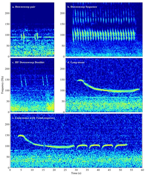
Spectrograms of Rice’s whale calls and potential calls.
See Soldevilla et al. 2024 for details of the data collection and analysis methods.
Progress & Results
Statistical analyses and manuscript preparation are currently underway. These analyses also include data from a fourth deployment funded by NOAA Office of Protected Resources in 2022-23. An additional year of data collection is planned to begin in April 2025 under Navy marine species monitoring program funding and will be incorporated into analyses when available. Finally, data collected during this project are being leveraged under NOAA-funded projects to acoustically track calling Rice’s whales throughout the core habitat and to evaluate feasibility of using spatially explicit capture-recapture methods for density estimation.
Project Information
Location: Northeast Gulf of Mexico
Timeline: 2019-2024
Funding: FY18 - $78K, FY19 - $395K, FY20 - $250K, FY22 - $59K
Points of Contact
Principal Investigator
Dr. Melissa Soldevilla
NOAA Southeast Fisheries Science Center
Project/Program Manager
Joel T. Bell
NAVFAC Atlantic
Environmental Conservation, Marine Resources Section
Deputy Program Manager
Jackie Bort
NAVFAC Atlantic
Environmental Conservation
Marine Resources Section
Reports & Data
2019 Technical Progress Report
2020 Technical Progress Report
2021 Technical Progress Report
2022 Technical Progress Report
2023 Technical Progress Report

