Behavioral Response of Humpback Whales to Vessel Traffic
Introduction & Objectives
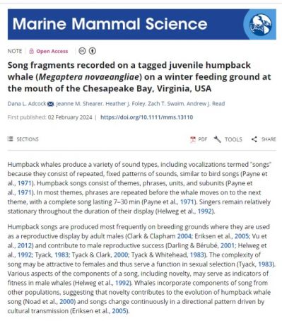
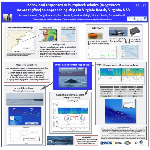
In the western North Atlantic humpback whales (Megaptera novaeangliae) feed in high-latitude summer foraging grounds off the East coast of the U.S. and Canada before migrating to Caribbean breeding grounds in winter (Katona & Beard 1990, Barco et al. 2002, Stevick et al. 2006). Since the early 1990s, juvenile humpback whales have been documented feeding in winter in coastal waters of the mid-Atlantic states (Swingle et al. 1993). The abundance of humpback whales in the North Atlantic is increasing (Stevick et al. 2003), but there are high levels of mortality in mid-Atlantic states (Barco et al. 2002). In 2017, the National Marine Fisheries Service (NMFS) declared an Unusual Mortality Event (UME) for humpback whales along the U.S. Atlantic coast. Since January 2016, more than 178 humpback whale strandings have occurred. Over half of these strandings occurred in the mid-Atlantic region, and although only approximately half of the whales were able to be examined post-mortem, 40 percent of those showed evidence of human interaction (ship strikes or entanglement).
The U.S. Navy has supported research on humpback whales near Virginia Beach since 2014 as part of the Mid-Atlantic Humpback Whale Monitoring Project. Satellite tracking data from this project shows that the distribution of these animals overlaps significantly with shipping channels (Aschettino et al. 2018). Given the UME, the large number of ship-related injuries, and the high spatial overlap with shipping channels, it is essential to understand the behavior of these animals around ships at the entrance of Chesapeake Bay.
In other areas, humpbacks have relatively low responses to anthropogenic sound such as sonar, especially when compared with other species (Sivle et al. 2015, Wensveen et al. 2017). Recent work in Virginia Beach (V. Janik, University of St. Andrews, P.I.) indicates that these whales do not respond to startling sounds (V. Janik, pers. comm.) Other researchers have suggested that, when whales are engaged in feeding behavior, they are less responsive to approaching ships (Laist et al. 2001), although there is also evidence that foraging behavior is disrupted by approaching ships (Blair et al. 2016) or sonar use (Sivle et al. 2016). Therefore, these whales provide a unique opportunity to study state-dependent risk of ship strike injury and disturbance in a high-mortality area. Understanding the behavioral context in which they are most likely to both encounter and respond to ships can inform ways to change human behavior to lower the likelihood of detrimental encounters. Determining when and how these whales respond to ships can help with management directives to prevent ship strikes, improving animal welfare and human safety as well as lessening the mortality occurrence of a recovering population.
The objective of this work is to build upon the ongoing Mid-Atlantic Humpback Whale project conducted under the U.S. Navy’s Marine Species Monitoring Program by deploying high-resolution digital acoustic tags (DTAGs) to measure humpback whale responses to close ship approaches. The following questions will be addressed:
1. Do humpback whales respond to ship approaches, and if so, which behavioral or movement parameters change?
2. Which aspects of a ship approach (including the ship’s acoustic and behavioral characteristics) elicit which types of responses?
3. Does the behavioral context of the animal (foraging/nonforaging) affect the probability of responding to a ship approach?
Technical Approach
Digital acoustic recording tags (DTags) will be deployed on humpback whales in conjunction with focal follows of behavior of the tagged whales. These tags will provide the opportunity to study the whales’ three-dimensional movement and reactions to the sound of vessel approaches. The acoustic recorders on the DTAGs will collect information on the acoustic profile of the nearby large vessels, including the received levels of sound at the animal and the frequency characteristics of the ship noise. Kinematic parameters recorded by the tag will be used to categorize animal behavioral states (foraging, traveling, other) and measure direct avoidance responses. At each surfacing during the focal follows behavioral state, distance and bearing (to recreate the whale’s track), and estimated distance to the nearest ship will be recorded.
AIS data will be utilized to collect additional information on vessels, including their size, speed, and course of the focal vessel and other ships in the area. Photo-ID images of the focal whale and its associates during the focal follow and biopsy samples will also be collected. Photo-ID images will be shared with colleagues from HDR and contributed to regional catalogs. Biopsy samples will be contributed to the sample collection curated by HDR.
Initial fieldwork for this project will be conducted over a period of two months in the winter of 2018/19, during suitable weather windows. The DTags will be programmed to record for 4 to 6 hours per day, which will allow for multiple ship approaches per animal, and facilitate collection of synoptic behavioral observations. Typically, we will deploy a single tag each day, unless a tag detaches early. Fieldwork will be conducted from the R/V Richard T. Barber with a team of 4-5 individuals, including three field scientists from Duke. The Duke field team will be based in Beaufort, North Carolina and travel to Virginia Beach when weather is conducive for tagging.
Efforts will be made to coordinate DTag deployments with individuals previously tagged with longer term satellite-linked tags (SPOT or SPLASH) to provide days to weeks of movement and behavior data providing additional context for the high resolution short-term DTag deployments. Ideally, individuals will carry both types of tag simultaneously.
Progress & Results
Four seasons of tagging effort have been completed (2019/20-2022/23), with the objectives of increasing the sample size of tagged whales, extending tag deployment durations (including overnight tag deployments when weather allows), and deploying DTAGs on whales equipped with satellite-linked tags deployed by HDR Inc. The aim is that this approach will: (1) improve the accuracy of location estimates for whales that are part of the vessel-response project and (2) provide fine-scale information on the diving behavior of satellite-tagged whales. Both of these projects contribute to ongoing efforts to understand the behavior of juvenile humpback whales in the Virginia Beach area and to better understand risk factors and develop potential mitigation measures for ship strikes. A total of 15 DTAG deployments have been made across all field season, several with accompanying satellite telemetry tags deployed by HDR.
Duke’s 2023 field effort consisted of prey-mapping, utilizing an EK80 high-precision scientific echo sounder in the shipping lanes of the study area. Of particular interest is determining whether prey density is higher within the shipping channels than in adjacent waters. Two separate surveys were designed for this field season: a systematic survey to map the main channel and a focused survey around a tagged whale. The goal of the systematic survey was to map the prey fields in the main shipping channel south and east of the turning basin. This area was chosen due to overlap between the spatial positions of humpback whales satellite tagged in previous years by HDR, Inc. and consistent foraging within these areas detected during previous years’ DTAG deployments. The focused survey was conducted near a tagged whale in order to compare the whale’s behavior with in situ prey data.
Foraging behavior from all tags deployed to date have been analyzed, including quantifying foraging rates, diel patterns, and kinematics, and a manuscript is in review. The 2023 field season concluded the field effort portion of this project. Additional analyses are currently being conducted, including:
- Comparing prey survey results with known locations of foraging behavior from DTAG records to assess spatial and diel foraging patterns.
- Combining satellite tag locations, foraging lunges, and bathymetry data from animals tagged with both satellite tags and DTAGs to analyze fine-scale spatial context of foraging behavior (location in water column, use of shipping lanes)
- Analyzing behavioral responses to approaching ships, including foraging behavior cessation, water column use, and spatial avoidance.
2019 World Marine Mammal Conference, Barcelona, Spain
Project Information
Location: Chesapeake Bay and Nearshore Mid-Atlantic
Timeline: 2019-2024
Funding: FY19 - $95k, FY20 - $75k, FY21 - $80k, FY22 - $80k, FY23 - $60k
Points of Contact
Principal Investigator
Jeanne Shearer
Duke University, Nicholas School of the Environment
Duke University Marine Laboratory
Program/Project Manager
Joel T. Bell
NAVFAC Atlantic
Environmental Conservation, Marine Resources Section
Deputy Program Manager
Jackie Bort Thornton
NAVFAC Atlantic
Environmental Conservation, Marine Resources Section
Reports & Data
2019 Technical Progress Report
2020 Technical Progress Report
2021 Technical Progress Report
2022 Technical Progress Report
2023 Technical Progress Report
Associated Projects
Mid-Atlantic Nearshore and Mid-shelf Baleen Whale Monitoring


